John E Simpson Letter 24 February 1843
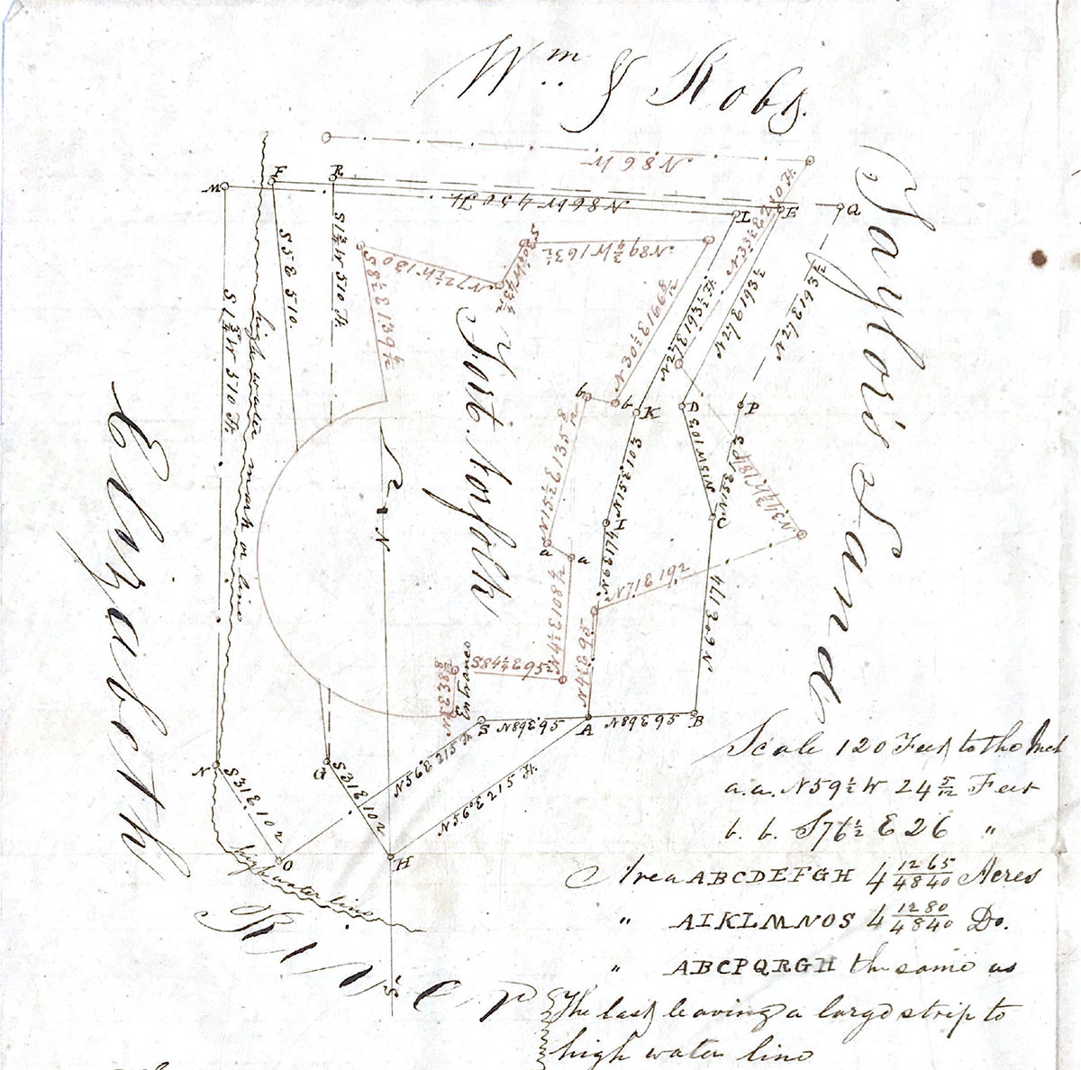
The above diagram exhibits three plans of the Public land at Fort Norfolk, arising from three different constructions which may be derived from the Deed; to wit ABCDEFGH which supposes A where there is a marked stone, and the only one to be found; to be the end of the first course from the river at H, and that the course from C is West, which is not definitely stated in the Deed.
The second plan ABCPQRGH suppose is A to be the end of the first course from the river at H, and that the unknown Course from C is Easterly.
The third plan AIKLMNOS suppose it is the mark stone at A to be the end of the second course, and that the beginning stone on the river side mentioned in the Deed, is at O; if this plan be the correct one the undefined course at I must be Easterly, as a Westerly course would be intercepted by the wall of the Fort.
With reference to the to first mention Plans, that portion of the curved part of the wall that lies over the lines GF, and GR, being on the river might have been extended over the boundary given in the deed. Should the lines of the last mentioned plan be adopted, the outwork on the Eastern side of the Fort would be considerably on Taylor's land as the plan will show.
The lines in red ink show the outline of the Fort and the extent of the outwork. The river line shows the location of the lines of the plan with respect to high water.
John E Simpson Sur N. Boro
February 24, 1843
P. S. What Mr. Simpson calls “Out Work” is nothing more than the counter carp; this is a small place of arms however in front of the Curtain. DR
Fort Norfolk Documents
1790, 1791, 1792, 1793, 1794, 1795, 1796, 1797, 1798, 1799,
1800, 1801, 1802, 1803, 1804, 1805, 1806, 1807, 1808, 1809,
1810, 1811, 1812, 1813, 1814, 1815, 1816, 1817, 1818, 1819
1820,
1840, 1841, 1842, 1843, 1844, 1845, 1846, 1847, 1848, 1849,
1850, 1851, 1852, 1853, 1854, 1855, 1856, 1857, 1858, 1859
1860, 1861, 1862, 1863, 1864, 1865, 1866, 1867, 1868, 1869
1870, 1871, 1872, 1873, 1874, 1875, 1876, 1877, 1878, 1879
1880,
Source of Information
National Archives, Record Group 77 (Office, Chief of Engineers)
Land Papers
Virginia (Craney Island, Mill Creek Bridge, Ferry Point, Ft. Norfolk, Yorktown Monument, Arlingtron Estate, Willoughby Spit);
Washington (General)
Box No. 61, NM-19, Entry 171